The MightyMoRiver Project
Trolling Missouri River info streams.Verified
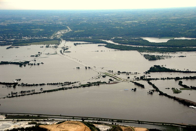
PHOTO - I-680 & I-29 @ Council Bluffs - #2011MoRivFlood #omahaFlood - via @Wikipedia
19:10 Jul 7 2011 I-29 & I-680 Interchange @ Council Bluffs, IA & Omaha, NE
Description
Council Bluffs, IA & Omaha, NE - 6/16/2011Interchange with I-29 looking toward Mormon Bridge from Council Bluffs on June 16, 2011 during the 2011 Missouri River floods
- I-680 & I-29 Interchange Article @ Wikipedia
- I-680 & I-29 Interchange Photo @ Wikipedia
- Google Street View: I-680 & I-29 Interchange
News Source Link
http://en.wikipedia.org/wiki/Interstate_680_(Iowa%E2%80%93Nebraska)http://en.wikipedia.org/wiki/File:Corp_of_Eng._6-16-11A_219.jpg
http://maps.google.com/maps?q=Council+Bluffs,+IA&hl=en&ll=41.352781,-95.905237&spn=0.012531,0.038581&sll=37.0625,-95.677068&sspn=58.988897,79.013672&z=15&layer=c&cbll=41.352775,-95.905254&panoid=bIbiIdTGmv3_z7FShuKCTA&cbp=12,241.8,,0,-5.56
Features
| Credibility: |  |
 |
0 |
Additional Reports
VIDEO - Council Bluffs & Sioux City, IA - #omahaFlood #suxFlood - via @KCAUtv @mercysiouxcity
23:16 Jul 06, 2011
Council Bluffs & Sioux City, IA, 1.1 Kms
Missouri River flood closes I-29 at Council Bluffs, again - DesMoinesRegister.com
11:23 Jun 18, 2011
I-29 @ Council Bluffs, 1.6 Kms
MightyMoRiver: I-680 Reopens! #2011MoRivFlood #OmahaFlood #SUXflood http://t.co/3ZpJKkdE
21:30 Nov 07, 2011
Omaha, NE, 3.01 Kms
Coast Guard closes portion of Missouri River MightyMoRiver: RT @OmahaUSACE:
16:42 Jul 12, 2011
Missouri River, 4.04 Kms
Video - Crescent, IA - 7/11/11 - Iowa DNR documents flood damage - #suxFlood #omahaFlood #2011MoRivFlood
15:03 Jul 12, 2011
Crescent, IA, 4.91 Kms
Leave a Comment